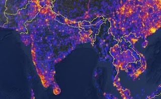
Are you more into experiential travel than resort relaxation? Want more adventure than you do tourism? Estonian coding firm Bluemoon Interactive , working in conjunction with travel photo-log Panoramio, has designed two new interactive travel maps that detail less-touristy and more interesting, remote destinations.
The world touristiness map has colour coded destination hotspots, derived from the quantity of a specific destination's corresponding photos found on Panoramio. The more warm the destination's colour, the more touristy it is.

The world touristiness map has colour coded destination hotspots, derived from the quantity of a specific destination's corresponding photos found on Panoramio. The more warm the destination's colour, the more touristy it is.

Similarly, the interesting remote places map colour codes destinations that are away from cities, but no less fascinating, whether highly accessible or not. For example, certain Greek islands may be coded red, identifying them as interesting destinations with high accessibility/visitation rates. Whereas certain destinations in the Amazon basin may be coded green, identifying them as extremely remote places of interest. Locations that are undocumented on Panoramio, or that are cities, are coded grey.
These maps are of great benefit for those looking to trailblaze off the beaten path, or at the very least, visually identify where mainstream travel trends lie. For example the "rite of passage" European tour renders the conteninent a fiery array of hot colours, whereas the midnight blue of much of Africa so poetically corresponds to Joseph Conrad's Heart of Darkness.
As a Canadian, I can't help but find interest in the tourist maps's depiction of Canada, a sharp reduction to the already southern and coast concentrated demographic maps. The flares of the Ontario-Quebec corridor and southern British Columbia are a fantastic contrast to the deep blue-black of the rest of the country, reminding me that there is still much adventure to be had in my own backyard.
As a Canadian, I can't help but find interest in the tourist maps's depiction of Canada, a sharp reduction to the already southern and coast concentrated demographic maps. The flares of the Ontario-Quebec corridor and southern British Columbia are a fantastic contrast to the deep blue-black of the rest of the country, reminding me that there is still much adventure to be had in my own backyard.

No comments:
Post a Comment